Weather Systems
Featuring Icebergs
Disclaimer
I am not a trained meteorologist nor am I an expert in the movements of icebergs and ocean currents. This document and the maps held within should be viewed as educated guesses made by an autist who likes thinking and reading about weather events, as long as they remain comfortable and easy to understand. Information held within is not and should not be seen as any sort of absolute authority on how the weather events of Vitubia work, but I do believe that the things documented here are plausible, and probably would be how these systems look like in Vitubia.
So, take a spoonful or two of salt and read on.
Vitubian Cyclones
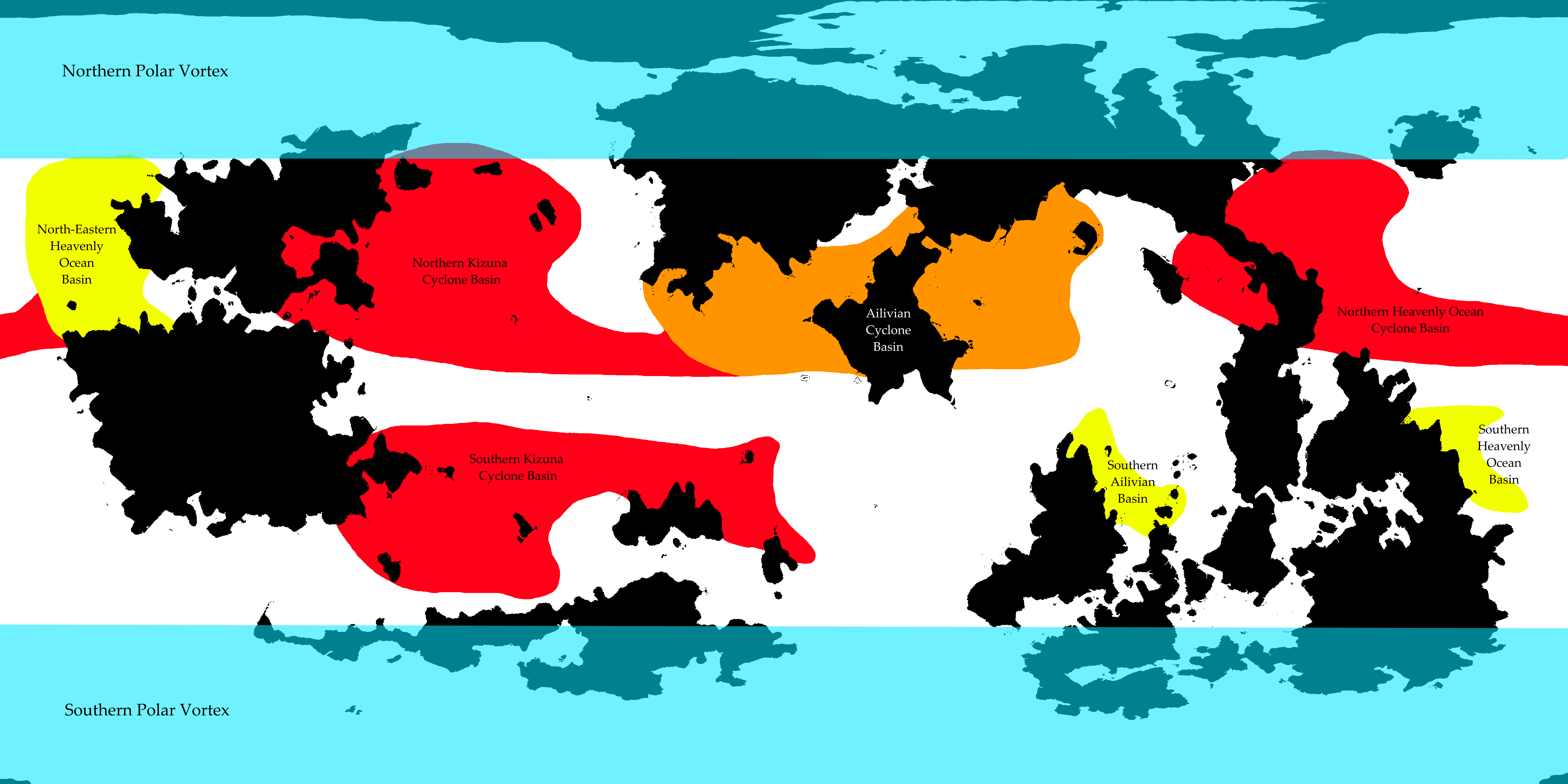
 Map of the Vitubian Cyclone Forming Basins including the probable usual extent of the Vitubian Polar Vortices
Note: The ENSO may affect the number and intensity of tropical storms in any given area. See ENSO below.
Major Basins
Northern Kizuna Cyclone Basin
Northern Kizuna Cyclone Basin is by far the most active cyclone forming basin on Vitubia. It is most comparable to Earth's Northwestern Pacific Ocean basin, although it is not as active. Most of the storms make landfall on the northern Indie continent, although it is not impossible for a freak storm to sometimes make its way to the Holocontinent, where it would make landfall in Republic Owl (/who/) or G.P.D.A (Hoshiyomia). By the time the storm would get there however, it would have been severely weakened and would most likely not be of Typhoon class anymore. It is not impossible for a typhoon to make its way to the Holocontinent however, but these events would be incredibly rare, at most once a century, but probably even less frequent.
Storms occur year-round, but the activity is at a minimum during the early spring months (February-March), and at a maximum during the summer and autumn months (June-November), which is the Cyclone Season for the area.
The numbers given below are approximations for the average number of the indicated event per year.
Total Tropical Cyclones: 20-24
Of which Typhoons: 8-12
Of which major Typhoons: 3-4
Retro Reich (/vrt/) is the area worst hit, with an approximate 5-7 cyclones making landfall each year.
Southern Kizuna Cyclone Basin
Southern Kizuna Cyclone Basin is somewhat comparable to the Northern Kizuna Cyclone Basin, although it is a bit less active owing to the existence of landmasses dotting the Southern Kizuna Ocean. The Southern Kizuna Cyclone Basin is the thirdmost active of the Vitubian Cyclone basins. Storms sometimes make their way to the Fetishcontinent. This would be rare, but not as rare as the equivalent for the Northern Kizuna Cyclone Basin, discussed above.
Storms occur year-round, but the activity is at a minimum during the summer months (June-July), and at a maximum during the winter and spring months (November-May), which is the Cyclone Season for the area.
The numbers given below are approximations for the average number of the indicated event per year.
Total Tropical Cyclones: 12-16
Of which Typhoons: 4-8
Of which major Typhoons: 3
Pyon is the area worst hit, with an approximate 4-6 cyclones making landfall each year.
Ailivian Cyclone Basin
Ailivian Cyclone Basin is the fourthmost active basin on vitubia. The basin is split in two by the /ggg/ peninsula, with the Eastern side of the basin being more active than the Western Side. The basin is most comparable to Earth's North Indian Ocean basin. The cyclones in this area are fewer and tend to be weaker compared to the other major basins. Occasionally the storms travel southwards and make landfall in Yectic Teocuacayotl (/meat/) and even more rarely, the Serene Republic (/Nasfaqg/). This occurrence is uncommon, but not rare: Approximately 1-2 times a decade, occurring most often when the seas around Yectic Teocuacayotl (/meat/) are in the warm, low-pressure phase of the Kizuna ENSO cycle.
Storms occur year-round, but are most common shortly before and shortly after the monsoon season, giving the area two shorter cyclone seasons instead of one longer one. These seasons are most likely to be early summer (May-June) and winter (October-December).
The numbers given below are approximations for the average number of the indicated event per year.
Total Tropical Cyclones: 4-8
Of which Typhoons: 0-2
Of which major Typhoons: 0
/ggg/ is the area worst hit, with an approximate 1-3 cyclones making landfall each year.
Northern Heavenly Ocean Cyclone Basin
Northern Heavenly Ocean Cyclone Basin is the secondmost active basin on Vitubia. The basin is most comparable to North Atlantic Ocean basin. Hurricanes and Cyclones in this area can sometimes make their way over the HoloID isthmus and strike Moriji (/Morig/), although by the time the storm would make landfall on the island it would be severely weakened to the point where they would have lost their hurricane status. However, this event would not be rare, and may happen annually. Cyclones in this area can also sometimes make landfall in Infinitum (/∞/), but like with the Kizuna Ocean Basins equivalent events, this would be rare.
Storms occur year-round, but the activity is at a minimum during the winter and spring months (January-April), and at a maximum during the late summer and autumn months (July-October), which is the Cyclone Season for the area.
The numbers given below are approximations for the average number of the indicated event per year.
Total Tropical Cyclones: 14-18
Of which Hurricanes: 6-10
Of which major Hurricanes: 3
Oiseau (/mep/) and Deuxlunesia (/moon/) are the worst hit, with an approximate 4-6 cyclones making landfall each year.
Minor Basins
Southern Ailivian Basin
Among the minor basins, the Southern Ailivian Basin is the least active. The basin experiences tropical storms, but they rarely develop into proper cyclones or typhoons.
Storm activity is at a minimum during the summer months (June-July), and at a maximum during the winter and spring months (November-May). Since proper cyclones are rare, there is no cyclone season in the area.
The numbers given below are approximations for the average number of the indicated event per year.
Total Tropical Cyclones: 0-1
Of which Typhoons: 0
Of which major Typhoons: 0
Yectic Teocuacayotl (/meat/) is the area worst hit. The Serene Republic (/Nasfaqg/), /indie/, and /#/ are also occasionally hit by storms forming in this basin, with the Serene Republic being hit far more often than the other two.
North-Eastern Heavenly Ocean Basin
Among the minor basins, the North-Eastern Heavenly Ocean Basin is the most active. It is the only minor basin that experiences annual cyclones.
Storm activity activity is at a minimum during the winter and spring months (December-May), and at a maximum during the summer and autumn months (June-October). Since proper cyclones are rare, there is no cyclone season in the area.
The numbers given below are approximations for the average number of the indicated event per year.
Total Tropical Cyclones: 1-3
Of which Hurricanes: 0-1
Of which major Hurricanes: 0
North-Eastern Heavenly Ocean storms usually do not make landfall, instead traveling West and Northwards to the Heavenly Ocean. However, when the storms make landfall, they are most likely to hit Arestsaviel (/jidf/).
Southern Heavenly Ocean Basin
Among the minor basins, the Southern Heavenly Ocean Basin is the secondmost active. The basin experiences tropical storms, but they rarely develop into proper cyclones or hurricanes.
Storm activity is at a minimum during the summer months (June-July), and at a maximum during the winter and spring months (November-May). Since proper cyclones are rare, there is no cyclone season in the area.
The numbers given below are approximations for the average number of the indicated event per year.
Total Tropical Cyclones: 0-2
Of which Hurricanes: 0
Of which major Hurricanes: 0
Tsukinode Teikoku (/2434/) is the area worst hit.
Vitubian Polar Vortex
A circling current of air in the polar regions of a planet, actually consisting of two kind of separate phenomena (Stratospheric Polar Vortex and Tropospheric Polar Vortex). Both have different effects on climate and weather, which I wont go into now due to me having spent the last 6 hours writing this document, leading to me experiencing an immense desire to move on to doing something else with my day.
In a nutshell:
It is possible in areas close to the Polar Vortex zone to experience sudden cold snaps when the polar vortex weakens for whatever reason. Since the high-speed cyclonically rotating winds that are the polar vortex function as a sort of "barrier" keeping the high pressure polar air mass within an area polewards of the polar jetstream, in an event where these strong winds weaken the high-pressure polar air mass can begin to travel towards the equator, in turn leading to potentially catastrophic weather events such as blizzards and uncharacteristically cold weather for areas not accustomed to it.
When this happens, you get fun events like heavy snowfall in the subtropics, and deadly cold weather in the temperate zones, perhaps even in the poleward parts of the tropics. On Earth in 2014 an event like this caused a climate type BSh area in Mexico to get snow.
Vitubian ENSO
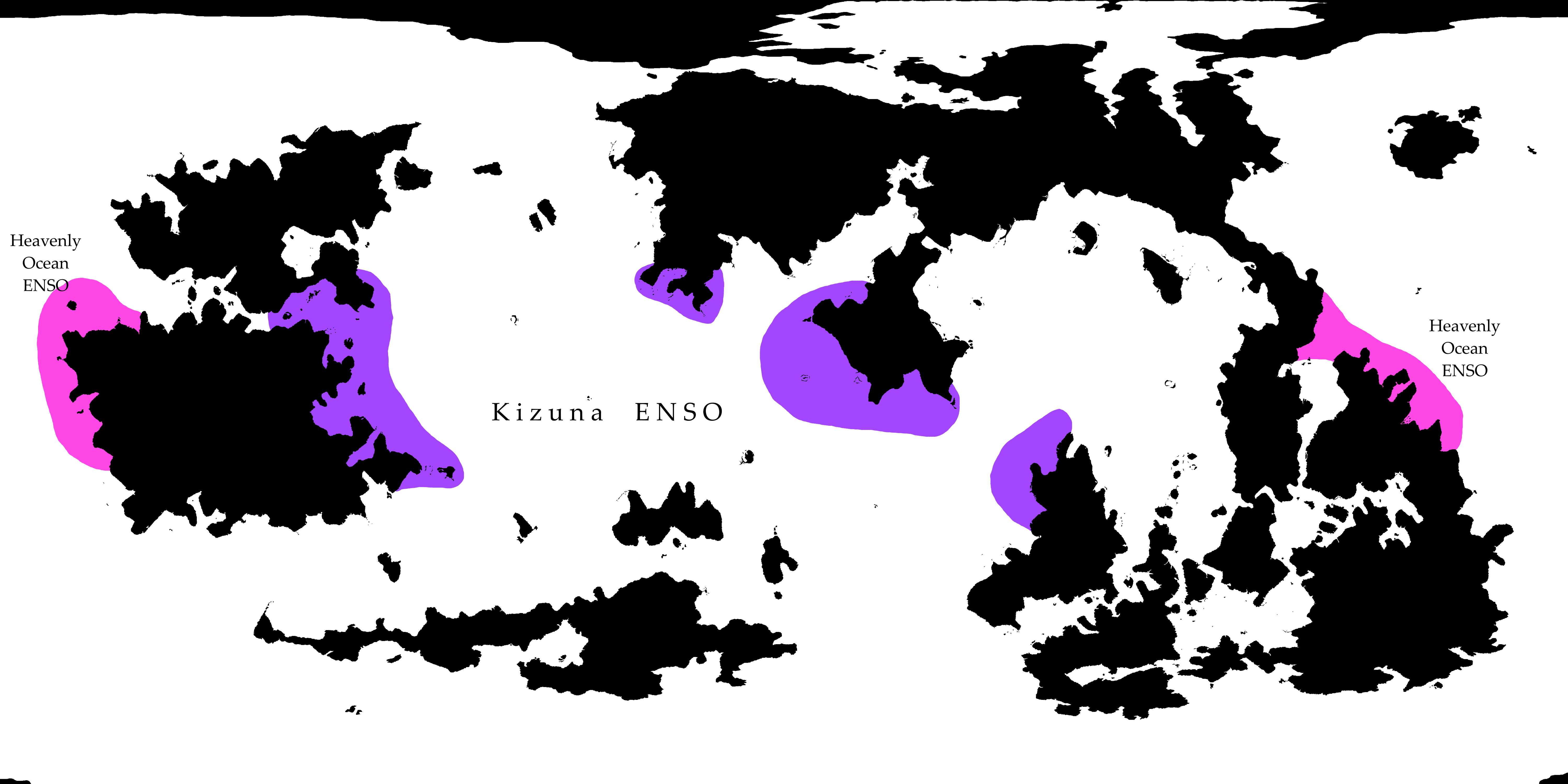
 Map of the Vitubian ENSO's effects
These area areas that experience ENSO (El Niño–Southern Oscillation). Essentially, for a few months every one or two years one side of the two coloured areas experiences heavy storms and flooding, while the other side experiences droughts and heatwaves. After the extreme weather dies down both of the areas get relatively normal weather followed then by the areas flipping; The one that initially experienced droughts is now experiencing storms and flooding, and vice versa. Then the cycle repeats.
For further reading, consult Wikipedia (Walker Circulation), (ENSO), or some other source.
Kizuna ENSO
Kizuna Ocean experiences the strongest ENSO on Vitubia, although the Kizuna ENSO is not as powerful as the one occurring on Earth's Pacific Ocean.
Heavenly Ocean ENSO
Heavenly Ocean ENSO is a fairly mild one compared to Earth's Pacific ENSO or Vitubia's Kizuna ENSO. It is much more comparable to the Atlantic Equatorial Mode, which is essentially like the Pacific ENSO but for the Atlantic Ocean.
Icebergs and their Extent
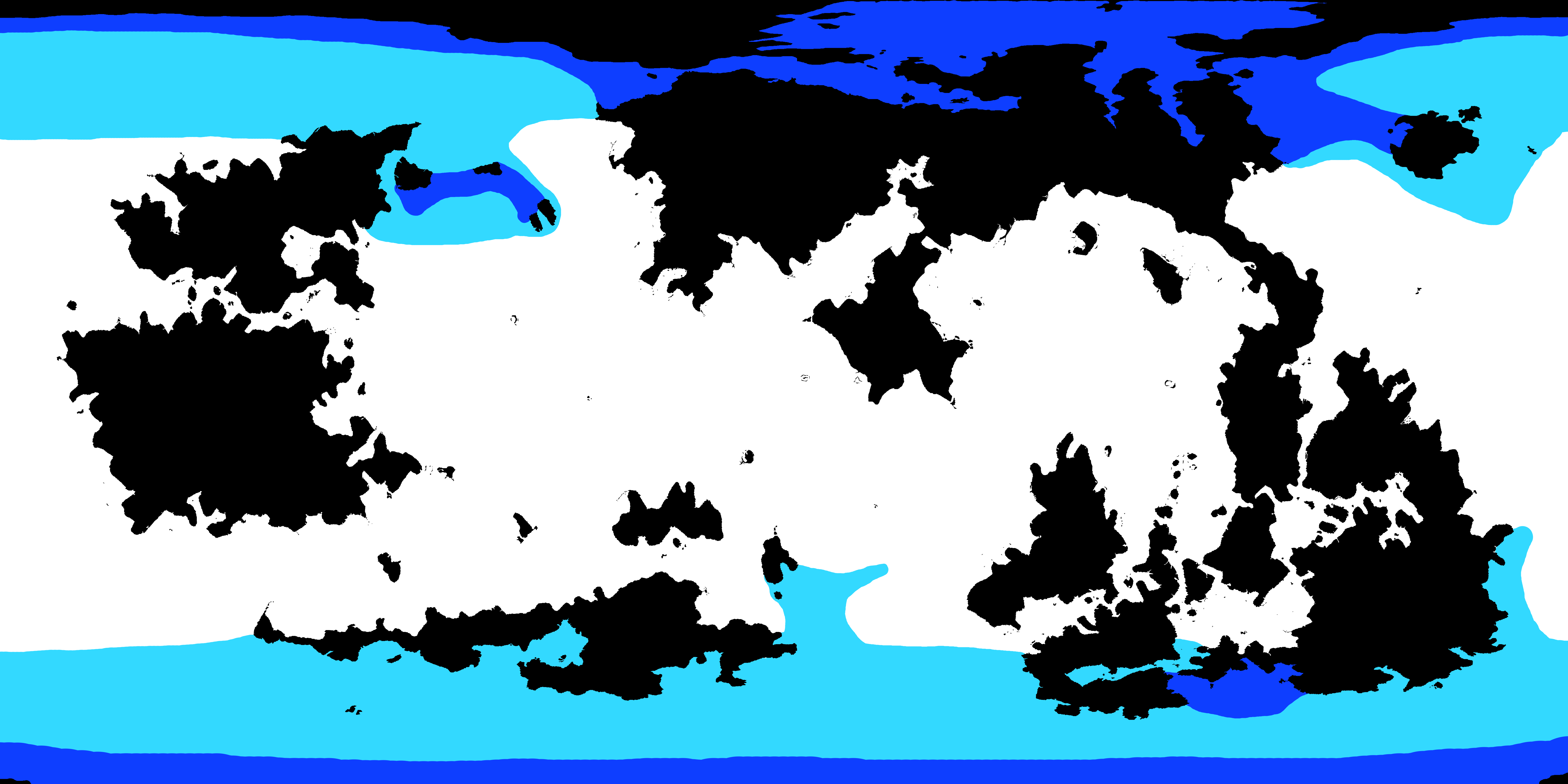
 Light Blue: Areas where floating icebergs are occasionally encountered.
Dark Blue: Probable iceberg hotspots. Areas where icebergs originate from, or areas where ocean currents may trap floating icebergs for an extended period of time.
White: Areas where icebergs are rarely encountered. It is possible for an iceberg to cross the equator, but this is a very rare occurrence.
On the topic of icebergs and their movement
You all probably know the iceberg basics; Big floating pieces of ice, most of them underwater, can travel the oceans for years before finally melting. The movement of icebergs is primarily guided by ocean currents and the wind, and the above map is made to reflect this. As I do not know the exact extent of the northern and southern iceshelves, its currently impossible for me to draw the exact areas from where icebergs would originate. The map also does not take into account the possibility of icebergs originating from other glacier sources, such as the /uoh/ glacier. I did not include these areas because of my lack of knowledge on the canonicity of massive glaciers bordering the oceans.
I'll briefly talk about the unusual dark blue areas:
Axia Coast and Northern Kizuna Ocean
Here, a cold northern current from the polar regions of the Kizuna Ocean brings icebergs southwards, until it meets a powerful warm ocean current originating from the equator, the Vitubian equivalent to the Gulf Stream. The two currents interact and mix, and the powerful equatorial current turns into the North-Kizuna Drift current, flowing North-Eastward (On the current map, simplified as an Eastward movement). This drift current flows past and around the islands of the Northern Kizuna Ocean, and is in turn slowed down and deflected by the islands, creating a slow, turbulent current in the area. Any icebergs carried by this current would move slowly past these islands, circling around in the eddies of the drift current and collecting along the coasts of Axia (/Rumina/) islands and the Northern Kizuna Islands, and sometimes even being caught by the Northern polar current for another round in the ocean current carousel.
Since the current here is quite warm, the icebergs would most likely melt faster than in the other iceberg trap zones, meaning that the Rumina Coast & Northern Kizuna Ocean iceberg trap would have the fewest number of icebergs among the iceberg hotspots. The icebergs here would likely also be the smallest among the iceberg traps.
Infinitum Western Seaboard
In this area the situation is somewhat analogous to the one encountered in the Northern Kizuna Ocean. The Nordic Polar Current originating from Northern Kizuna Ocean and flowing next to the Northern polar continent carries with it floating icebergs it picks up along the way. Once the current encounters the Eastern coast of the Holocontinent, it is deflected southwards where it is met by a weaker warm current originating from the equator in the Heavenly Ocean. The two currents interact and mix, forming two small turbulent gyres west of the Infinitum Island. Icebergs carried by the Nordic Polar Current are trapped and concentrated in these gyres.
As the warm ocean current here is not as strong and not as warm as the one encountered in Northern Kizuna Ocean, any icebergs would last much longer here. It may be plausible for an iceberg to be trapped in this area for years before finally melting away, or being driven further south by the current flowing past Infinitum's southern coast. Among the three notable iceberg traps, the Infinitum Western Seaboard trap is most likely the one populated by the most icebergs at any given time.
Southern /kr/ Gulf
The most unique among the iceberg trap areas, and also the most simple. Here, the Southern Circumpolar Current flows past the Southern coast of the Neutral-Niji Continent, and creates a small gyre in the gulf shared by Mujigae-Vinägy Hanhöm (/kr/) and Pingviinilä-Wælseaxɑksnɑ (/Anya-Petra Global/). Floating ice carried by the Southern Circumpolar Current sometimes get trapped in this gyre, and thus collect in the gulf and along the shores of the nations here.
Since the currents that make up the gyre are cold, and since the area is so close to the polar regions, icebergs trapped here may remain here for years, even decades, before melting away completely. Most icebergs that pass through the gulf are eventually picked up by the Southern Circumpolar Current and carried elsewhere, but some icebergs may stay circling the gulf gyre until they melt away completely, or get trapped in shallow waters near the shores. Among the three notable iceberg traps, the Southern /kr/ Gulf trap is the secondmost populated one. Although the icebergs here have longer lifespans than the ones found in the Infinitum Western Seaboard or the Axia Coast & Northern Kizuna Ocean traps, the Southern Circumpolar Current is about equally as likely to remove ice from the gulf as it is likely to deposit more into it, meaning that the number of icebergs in the Southern /kr/ Gulf would be somewhere in between the other two traps. Notable is, that the icebergs in this area are likely on average the largest of the three traps, owing to the colder oceans and more recent origin of the icebergs.